
September 10, 2005
Pure alarmism
The Toronto Star seems bound and determined today to make Torontonians more worried about emergency preparedness. Which is not at all a bad thing, but not when it's made with dishonest arguments.
First up, columnist Ian Urquhart, questioning the emergency management commissioner's entirely reasonable belief that a total rapid city-destroying catastrophe is not something Toronto needs to plan too much for:
But then Fantino expressed doubt about Ontario's cities having to face a disaster of the scale of what hit New Orleans and environs. Noting that the province is not on an earthquake fault line or in a hurricane zone, he said: "I don't envisage us being in that kind of catastrophe."
What about a major accident at, say, the Pickering nuclear plant?
"There are redundancies and safeguards in there (Pickering) galore," said Fantino. "I don't think that we'll ever have that kind of a problem. But one never says never. We have to revisit everything."
I've been on the periphery of the nuclear industry all my life. Plans for evacuations of immediate local areas in case of an accident should always be on the books, of course. But I have never heard of a plausible scenario where an accident at any Canadian reactor would require the evacuation in a matter of only hours of hundreds of thousands of people, or pose any risk of widespread property loss. Alarmism, pure and simple. Fantino is right... barring nuclear bomb or meteorite strike, the kinds of disasters that can realistically hit Toronto involve localized evacuations of a neighbourhood (river flooding, chemical spill), or widespread loss of essential services city-wide (power outage, ice storm). The kind of catastrophic disaster New Orleans needed to be prepared for (or Vancouver does, for that matter) is simply not plausible here.
There's no doubt everybody's disaster plans should be reviewed post-Katrina. But any time spent planning the mass evacuation of Torontonians today would be wasted time. Better to focus on how to maintain city-wide services in a regional service-loss situation like an ice storm (ie, getting food in, not getting people out) and how to build redundancy and scalability into the first-response services, like the police, to prevent them being overwhelmed the way New Orleans police were.
Then you have Peter Calamai, talking about the 173 tropical storms that have hit Canada in the last 105 years, causing up to 895 deaths. Sounds scary, no? Sure, until you drill into his figures a little and find out that 847 of those deaths and disappearances occurred before 1955, and 678 of those were in boats at sea. In the entire second half of Calamai's survey period, from 1955 on, only 48 Canadians have died in tropical storms, less than one a year, a twentieth of the death rate in the previous five decades. He does however, rightly point out that the greatest difference between 100 years ago and today is accurate weather forecasting, limiting the exposure of fisherman and other boats at sea to these storms. There can be no doubt that the advent of modern meteorology has probably saved hundreds of Canadian lives in this way.
Absolutely, the Atlantic provinces need to be prepared for the worst from tropical storms, but what Calamai elides over is that Ontarians, shielded by the Appalachians, aren't at significant risk here. Calamai doesn't mention it, but his 1900 "worst storm ever" only killed one person in Ontario, although it devastated the Atlantic provinces. With the singular exception of Hurricane Hazel in 1954, which hit Toronto smack on, killing 81 (almost all of them due not to the winds, but the resulting flooding of local rivers due to an unbelievable amount of rainfall), tropical storms have never been a significant mortal threat to Ontarians. As we showed this summer, Toronto-area rivers are still occasionally vulnerable to localized but intense river-flooding even without the involvement of a hurricane... the same measures that are needed to protect riverbank residents from that kind of disaster, combined with a dose of common sense (don't drive or fly in a big storm, and definitely don't go out in a boat) and the hardening of essential services like communications and power delivery, would seem sufficient protection from this threat.
Gretna city limits, pt 2
Okay, maybe a graphic can show this more clearly, as Kevin Drum and a couple others are really muddying things up with inaccurate maps. Here's the big picture. 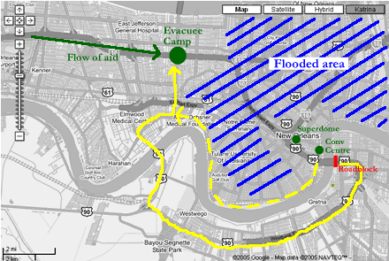
The flooded area is marked, as are the two downtown collection points, and the Gretna roadblock. The closest point of aid for evacuees was the major collection point that had been established at the junction of the I-10 and the Causeway Road, to the west of New Orleans in Metairie (big green dot), which in turn was supplied from the airport. To help people, they had to get to this point (assuming officials continued to deny relief officials entry into the city proper, but that's another issue).
The yellow solid line is the route, nearly 20 miles by my rough estimate, crossing the Mississippi twice, that was effectively blocked by Gretna police. The dashed route, along the high ground on the north side of the Mississippi, is the route that it appears a significant number of individuals (including the two EMS techs) ultimately ended up taking to get out after it was clear the Gretna bridge was blocked.
On the morning of Thursday, Sept. 1, over two days after the storm cleared, with the arrival of buses at the Convention Center still 48 hours away, and both the Convention Center and Dome closed to new arrivals, if you were in New Orleans you would have basically had three choices, assuming no roadblocks. You could sleep in the street and wait for the buses to show. You could take the longer way out through Gretna if it was open. Or you could take the more direct route out, staying in New Orleans... still a long walk, maybe over 10 miles, but not as long as the alternative.
If I had been in New Orleans, all the other indignities would have been forgettable if just one person in authority had been able to say that morning, "Look, there's problems with the buses, but if you can walk for a few hours heading west, hugging the north bank of the river, you'll be fine." I'd have been sure to have made it out well before nightfall, and could probably have carried someone's small child if I'd needed to, as well, getting that child to medical aid two full days earlier than if they'd been left in the convention center.
I simply don't understand why someone didn't stand up in the Convention Center and tell people the situation, and encourage the able-bodied people there to start hiking west along the river that morning. That would have left whatever resources did make it through to the Centre in the next two days to be shared by the elderly, the infants, and the injured. No, it's true wheelchairs and baby strollers likely couldn't have made it easily along the northern-bank route... but reducing the numbers by letting the able walk out would surely have helped ease the pressure on the collection points and bus arrangements.
All the Gretna policewere blocking, it turns out, was a massive detour, that would only have increased the number of people falling out of the line of march, dropping out of sight even farther from the help they needed than when they set out.
Now, all this would have been greatly alleviated if the rescuers had been allowed by the state to deploy further forward, perhaps even with a staging area in Gretna. Of course, if they had had the buses and resources to deploy further forward at that point, they could have deployed them right to the convention center... since they didn't or couldn't, those stuck in New Orleans had to rely on their own devices. Just a little accurate and truthful information from authorities would have gone a long way here.
Side note: The southern bank of the Mississippi in this picture is called the West Bank, even when, in the case of Gretna, it is to the east of New Orleans. That's why Drum's map is wrong.
"endearingly macho" -- Mark Steyn
"wonderfully detailed analysis" -- John Allemang, Globe and Mail
"unusually candid" -- Tom Ricks, Foreignpolicy.com
May 2010
April 2010
March 2010
February 2010
January 2010
December 2009
November 2009
October 2009
September 2009
August 2009
July 2009
News:
The Globe and Mail
The Star
The Wash. Post
Opinion:
TNR
Slate
Washington Monthly
Rants:
Canadians
Penny
Janes
Cosh
The Hound
Coyne
Wells
Farrell, etc.
Steyn
Levant
Afghanistan
The Torch
Abu M.
Bill & Bob
Ghosts of Alex
Registan
Jari
Ink Spots
Ackerman
Kings
FRI
Embedded
Milnews.ca
Can-AFG
The Capt.
Etc.
TMLutas
Sullivan
Marshall
Kaus
Lileks
Reynolds
Welch
Farber
The Shark
Breen
Henley
Electrolite
Samizdata
Slotman
Simberg
Northrup
Bryant
Yglesias
Cole
Drum
Clients/Employers
(Past and Present):
U of T
Cdn. Forces
CG Magazine
LRC
Adrenaline Vault